A Walk from Wycoller
by Colne Life magazine
A walk by Adam Hargreaves
Wycoller was once a thriving village of hand loom weavers and farm workers with a population of several hundred but with the industrialisation of spinning and weaving many of the inhabitants moved away to the mills in nearby Colne and the village began a slow decline.
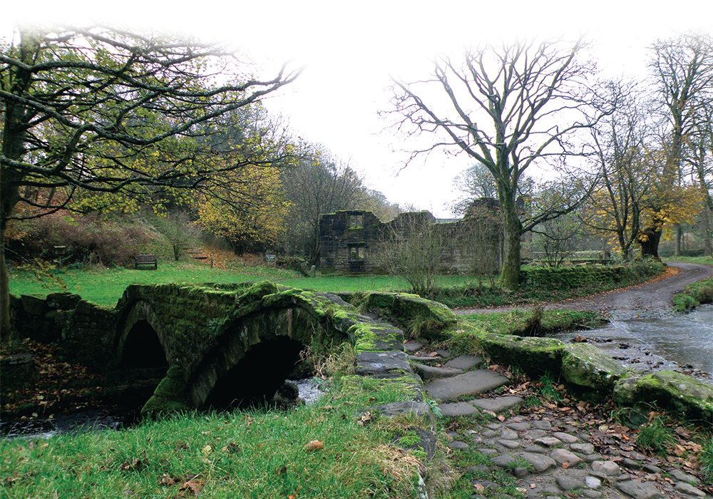
In the sixties when I first visited, it was a deserted place with an air of neglect butduring the latter part of the last century the cottages were restored and it began to attract visitors and was accorded the status of a Conservation Area. It is now one of rural East Lancashire’s top attractions. Visitors now wander where the sound of clogs used to ring and the picture postcard view of the packhorse bridge is framed in the viewfinder of thousands of digital cameras throughout the year.
Normal traffic is excluded from the village, all but local services and disabled vehicles having to park outside and walk in which helps to avoid the blight of parked cars everywhere. There is plenty to do if you decide to pay Wycoller a visit. There are some interesting displays in the Aisled Barn giving an insight into local life in the past and highlighting the importance of the village to the hill farmers in Wycoller Dene who would bring down their livestock for collection before driving them to market. The barn was used for storing fleeces and for threshing corn between the two big doors, allowing the wind to blow the winnowings away. If you look up to the impressive roof structure in the barn you can see how such huge structures were built. It is said that some of the curved timbers came from the hulls of broken up ships, an intriguing example of early recycling.
Wycoller Hall engages our attention. Now only a ruin, it was at one time a fine house suitable for a gentleman, reflecting his status and position in the area. It was seemingly the residence of the Cunliffe family from the seventeenth to the early nineteenth centuries when the last squire, Henry Owen Cunliffe died at the hall.
The estate was dispersed, the main part of the hall fell into disuse and in time much of the stone was used for building in other houses in the area. Henry by all accounts enjoyed cockfighting which is perhaps where the wealth of the family was swallowed up!
The hall is said to have been the inspiration for Ferndean Manor in Charlotte Bronte’s Jane Eyre. In the book it is described as being an ‘ineligible and insalubrious site’, terms that don’t spring immediately to mind today.
Certainly it is quite feasible that the Bronte sisters would walk here from the Parsonage at Haworth, no great distance for such sturdy walkers as themselves. As the light begins to fade on a winter’s day, this can be a lonely spot. Thoughts of the two ghosts that haunt the ruins come to mind, one a headless horseman (they get around, don’t they?) and the other a lady in black, glimpsed at a window.
Our walk starts at the Haworth Road Car Park up on the hill, partly so we can take a look at the ‘Atom’, one of the panopticons that began to appear on East Lancs hillsides soon after the Millennium. These are essentially art works which have been installed as landmarks in areas such as Burnley (The Singing Ringing Tree), Rossendale (The Halo) and Blackburn (Colourfields). They were the result of a competition organised by the Royal Institute of British Architects, the winners of which had their creations erected.
The Atom was won by Peter Meacock and Katarina Novomestska and you can decide for yourself if it was a worthy winner. It is basically an egg-shaped object with openings through which views of the surrounding countryside can be seen. Shelter, observation platform, sculpture, call it what you will, my only reservation is that there is nowhere in it to sit down if you have to shelter from the rain.
The Walk
From the car park, head down diagonally right to a gate and continue walking gradually downhill on a sunken lane called the Old Coach Road. To the right is one of the odd walls characteristic of the area, known as ‘vaccary’ walls from the French ‘vache’ meaning a cow. You couldn’t keep sheep out with walls like this but cattle were commonly reared here including oxen bred for work and the walls kept them penned. We come to a fork and take the left, arriving between the toilet block and the Aisled Barn in the village of Wycoller. The hall ruins are to the right with the Packhorse Bridge beyond, only wide enough indeed for a horse and rider, wheeled traffic had to go through the ford. The Craft Centre and Café is on the right as you go through the village and very nice it is too, not to be missed whatever the weather.
Returning to the Aisled Barn, we take the track that follows the beck away from the village, the beck to our right. Within a few hundred yards we notice a huge slab of stone laid across the beck to form a bridge. This is called the Clam Bridge, supposedly from the dialect word ‘clammer’ or clamber, the bridge at least 1000 years old. In more recent times it was dislodged by flash floods on two occasions but each time they have set it back on its mountings.
Continue on the track and after crossing the beck the way divides, our route keeping left and following the sign for the Pendle Way, a 45-mile circular walk around Pendle Hill, much associated with the witches. The stream is now to our left as we proceed to where Parson Lee Farm can be seen ahead. Look left and cross the footbridge over a tributary stream to a gate leading into rough pasture. Keeping slightly left, head across quite a wet field towards a house which you can see with a conservatory tacked onto it. This was once Foster’s Leap Farm, now restored as a private house.
The path crosses the back of the house then goes through a metal gate into an access lane, tarmacced for the use of the householder and for the bungalow that stands beside it. Take to this tarmac drive and wind your way up the hill taking a look at the jumbled grit stone rocks to the right. The highest point is known as Foster’s Leap named after Foster Cunliffe of the hall who for a bet made the leap across the two-metre gap. Candidly I would not like to try it. These rocks attract rock climbers, the arête graded at extreme.
At the top of the tarmac drive as it bends away to meet the road, keep ahead towards a line of telegraph poles and go through a kissing-gate. At the wall corner, head half left on a path that contours the hillside without varying much in height. Go through another of those vaccary walls and keep right at a marker post. The Atom appears ahead like the damaged egg of a giant bird and we arrive on a well-trodden path back at our starting point. Wycoller can seem rather a remote place at times but I find the more you visit it the more it grows on you. It seems to typify the gritstone resilience that you find in the people of East Lancashire and one’s respect for those who work in farming increases. How hard it must be to gain a living from this land!
Our walk has been quite short but there are several longer circuits you can do in the area as well as the long trails like the Bronte Way and the Pendle Way. Even the Pennine Way, whilst not touching Wycoller, passes quite near, easily accessed from Wycoller. There are many possibilities for the walker enough to merit an entire book! Perhaps I should write it!


