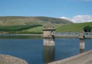
Ogden Reservoir and Fell Wood Walk (5 miles)
by Colne Life magazine
Click here to download and print the walk (PDF)
General history of Barley
 Barley, known as Barelegh in 1324, means the infertile lea or meadow. The Township of Barley included Barley Booth, Wheatley Booth and Hay Booth and Whitehalgh (now known as Whitehough) – “Booth” means cowsheds. About 1266 a cow farm was established, followed by extensive cattle breeding in the 13th Century. Barley earned its livelihood from agriculture until the 18th century when textiles were manufactured and handlooms were installed in attics of many smallholdings as an extra source of income. Barley’s brooks – as an effective source of waterpower attracted cotton factories. There was a small mill at Narrowgates and one at Barley Green, which is now the site of the water treatment plant. At its height Barley Green Mill worked 200 looms, until floods destroyed the building in 1880. A cotton twist mill at Narrowgates was built by William Hartley to spin cotton warp thread. Weavers cottages were built adjacent to the mill and are still occupied to this day.
Geological and geographical information
The area’s central feature is a north-westerly facing mounting escarpment – extending from Whalley to the Aire Gap – reaching it’s highest point at Pendle Hill (563m /1830ft). Pendle Hill and the Barley area are mainly formed from Millstone Grit of the upper Carboniferous series giving a typical harsh and windswept landscape with bracken, heather and cotton grass. The Pendle grit outcrop covers several square miles, including the mountainous tracts of Barley Moor and Pendle Hill. Scree and down-washed peat prevents the base of the Pendle Grit being exposed along the northerly slopes of Pendle Hill. Higher parts of Pendle Grit are intermittently exposed in the upper reaches of Ogden Clough and Boar Clough – it’s major tributary draining Barley Moor. Grit stone at about the same height forms low crags along the southern side of the valley between Upper and Lower Ogden Reservoirs.
 Forest of Bowland
Area of Outstanding Natural Beauty (AONB)
The Forest of Bowland Area of Outstanding Natural Beauty (AONB) is a nationally protected landscape and internationally important for its heather moorland, blanket bog and rare birds. The AONB is managed by a partnership of landowners, farmers, voluntary organisations, local councils and government agencies, who work to protect, conserve and enhance the natural and cultural heritage of this special area. For more information regarding the Forest of Bowland AONB, visit the website at www.forestofbowland.com or telephone 01772 531473 for an information leaflet.
Leaflets available from Barley Information Centre and Pendle Heritage Centre, Barrowford.
Public transport details telephone Travel Line 0870 608 2608.
Much of the land around Ogden and Black Moss forms part of a valuable water catchment area. The reservoir supplies drinking water and it is important to safeguard this supply. You can help by guarding against risk of fire, fastening gates, keeping dogs under proper control, keeping to paths across farmland and avoiding damaging fences, hedges and walls. Be careful on country roads and please protect wild life, plants and trees. When walking and riding in the countryside please follow the country code.


